


Directions:
Here's a link to the Dogtown location on Mapquest
You can get there via Cherry Street and Dogtown road. There is some parking available and this spot will get you to Dogtown commons the quickest. You'll have to walk a bit through the woods to get to the Babson Reservoir and the boulders
The best way to get to the boulders is to go to the end of Route 128, go through the Blackburn Circle rotary and enter the Blackburn Industrial park. Head towards the radio tower in the back. Park here then find the Old Rockport road just off the pavement. A trail breaks off here and you'll quickly be compelled to 'find a job'.
Click here for the Babson Boulders map.
The
Disclaimer! |
| August 20, 2006 - The following webpage is an excerpt from Tom Dresser's book "A Village Lost In Time". Used by permission from Tom Dresser. |
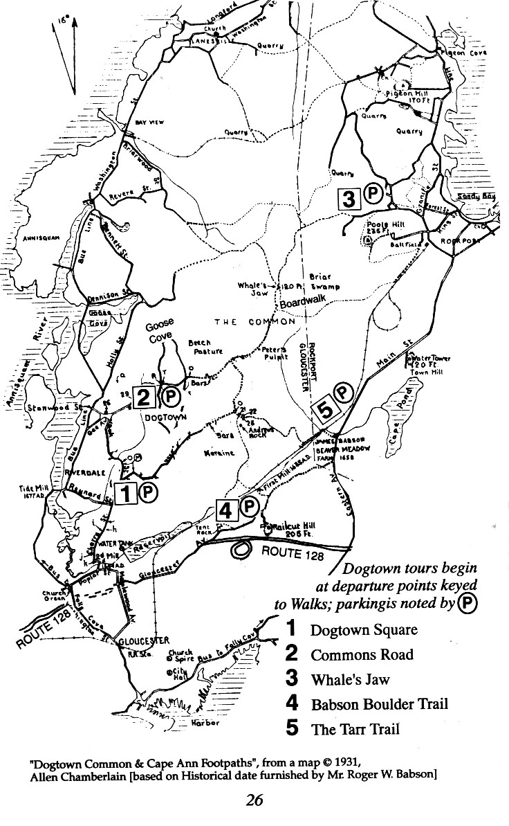 |
Dogtown Map (from A Village Lost In Time.pdf) (736x1193 pixels - 326k) |
DOGTOWN WALKS
Attempting to traverse the 3,600 acres of Dogtown without a map is a foolhardy venture. A compass may be useful, too but, because the terrain is so bumpy, it's easy to get lost if you stray from the trail All trees and boulders tend to look alike when you get turned around. While the trails are fairly smooth, it does help to have a good pair of walking shoes. Be aware that hunting season is October 19 through April 1, and hunting is allowed in Dogtown - but never on Sunday.
These five walks approach Dogtown from different directions and easily connect with one another, should time and interest allow. So, they can be done in an hour or two, combined, varied or changed to suit the condition of the hiker, the weather, and the time available.
WALK #1: DOGTOWN SQUARE
Route: From Cherry Street to Dogtown Square to Dogtown Commonand return. 30 minutes round-trip.
By automobile from Washington Street turn right onto Reynard
Street. Drive to Cherry Street and turn left 1 / 10 mile, past the Cape Ann Sportsman's Club. Take a right turn up a steep hill with a "Historic Dogtown" marker by the street. Go 3 / 4 mile to a small parking area by a gate. This is where Dogtown Road and your hike starts.
To the right is the Sportsman's Club. Walk 1/4 mile to a second gate, with the Gravel Pit on the right. Walk around the gate.
A pair of cellar holes are hidden on your left amid bushes and trees. Some other points of interest along this part of Dogtown Road include the cellar-holes of Dorcas Foster (#17), Isaac Dade (#18) and Granny Day (#20). [See the History section of this booklet.]
Dogtown Road winds gently through hilly pastureland that is becoming reforested. The road forks at Dogtown Square, identified with the carving "D.T. SQ." On the left just before the Square is "Granny Day's Swamp" where many a cow or sheep got mired in the mud. A covered cistern is on the edge of the tree-lined swamp. Blueberries are plentiful here.
Where Dogtown Road forks at the Square, take a right up the old cart road for a five-minute detour up to the Commons. This path winds among the trees, with virtually no view, although there are a couple of Babson's Granite Graffiti to see along the way: "If Work Stops Values Decay, and "Keep Out Of Debt". The Commons itself - your destination - is an open area suitable for picnics. Return by the above route.
To extend the walk a little further, proceed through the Commons and take the roadway to the right almost back on yourself and through an open field. Several massive boulders dominate the area. As you wander more to the left staying close to the trail, you can see evidence of the boulder and rock debris from the last Ice Age. This is where the Terminal Moraine is most dramatic.
Babson Boulder Trail goes off to the left through the Moraine (see Walk #4)
WALK #2 : THE COMMONS ROAD
Route: From Gee Street, around Goose Cove Reservoir; Commons Roadloop. 90 minutes round-trip.
The Commons Road was the center of town more than two hundred years ago. Now it is partially submerged beneath Goose Cove Reservoir. Still, it is a pleasant stroll along an easily marked road.
By automobile take Cherry Street to Gee Avenue and take a right to the end of the road. There is an ample parking area, marked by a "Historic Dogtown" sign. Park here and proceed on foot along the paved roadway to the Goose Cove Reservoir.
Go right on the paved maintenance road and walk 15-20 minutes or half-way round the Reservoir to the rutted and rocky Commons Road, leading up and away from the Reservoir. It is directly across the water from where you parked.
Proceeding up the Commons Road, at 1/10 mile take the fork to the right - Dogtown Trail- which leads to an open field in about five minutes. Notice the stand of white pine that rims the pasture. This is the remnant of Adams' Tree Farm. The grave of Rayne Adams is nearby. Continue on the trail across the field and up a wooded hill. Be careful not to stray. Five minutes later you emerge on Dogtown Road, near stone marker #17 (home of Dorcas Foster).
On Dogtown Road go left and proceed five minutes to Dogtown Square C.D.T. Sq.
At Dogtown Square go left onto Wharf Road. This road narrows into a footpath, but is not hard to follow. (It also hosts the very best blueberry bushes in Dogtown.) Along the way on the right is the cellar-hole of Abram Wharf (#24).
Wharf Road has a fork but both forks bring you back to the Commons Road in about ten minutes. Go left to return to the Reservoir. A right turn takes you further up Commons Road to Peter's Pulpit, certainly one of the more impressive boulders found in Dogtown. This massive boulder, the size of a dozen cars, is a detour of but a few minutes.
From Peter's Pulpit, it is 20 minutes back to the Reservoir and another 15 minutes beyond that to the parking area.
WALK # 3: WHALE'S JAW
Route: From Squam Road, Rockport, proceed to Whale's Jaw and Briar Swamp and return. 45 minutes round-trip.
Until 1989 Whale's Jaw looked like the head of a whale rearing out of the land to grasp an unwary hiker. But that year a fire was lit under the "jaw" and burned very hot for a long time. The bottom jaw broke off, leaving a somewhat less impressive sight, and affording more surface for graffiti. Yet, it still is worth the trouble to find it.
By automobile take Squam Road in Rockport for 1/2 mile and park at the gate barring vehicular traffic. There is a stone with the word "Dogtown" painted on it. Follow the trail for five minutes to a fork. Go left and walk along the trail for 10 minutes to Whale's Jaw.
From the Jaw continue down the hill to a T-intersection and turn left, heading through the woods. After a ten minute walk a small boardwalk will appear on your left. This is your path through Briar Swamp.
The boardwalk was constructed through the joint efforts of the Essex County Greenbelt Association and the Dogtown Advisory Committee in 1987. The red wine color of the water is caused by bog ore. A dike was built in the 1930s by the WPA to keep this red water from permeating the Babson Reservoir. This swamp is the source of Cape Pond Brook - also known as Alewife Brook or Wine Brook.
From Briar Swamp you may return to Squam Road by the route you followed in.
Until 1989, the Whale's Jaw natural formation was easier to spot than in its present state.
WALK #4: BABSON BOULDER TRAIL
Route: From Industrial Park to Babson Boulder Trail, Terminal Moraine, Dogtown Road loop; return. 60 minutes round trip,
By automobile via Route 128 go to the Blackburn Circle: get off at the exit marked "Industrial Park" Proceed 1/2 mile to the end of the park, staying to the left, avoiding the business area. Park by the broadcast tower on the left.
Walk back behind the tower along the cart-road. Shortly a branch forks to the right into an open field. Keep to the right and descend through the trees. A large boulder will suddenly recommend: "Get a Job " This is Babson Boulder Trail.
Continue descending, past "Help Mother" while enjoying views of the Babson Reservoir, to the tracks of the Rockport extension of the Boston and Maine Railroad. Cross the tracks but be cautious; this railroad still operates.
Follow the tracks to your right until you reach the measured mile
marker. Proceed up the steep hill to the Terminal Moraine. The geological spectacle of the many boulders is rivaled by Babson's N stone book of moralistic mottoes. Follow this trail fifteen minutes ascending and bearing to the right to reach Dogtown Commons.
At this point a pleasant 45-minute loop is possible. As you emerge from the Boulder Trail, bear right, past Uncle Andrew's Rock and into Dogtown Commons pastureland. Take an immediate left back and follow this roadway five minutes to Dogtown Square (D.T. Sq.). At the square, go left along Dogtown Road. This is a good 10 or 15 minute walk., past cellar holes and along a gravel road. When you corner to the gate, go around it and cross the roadway. As soon as you arc on the roadway, look left, at three large boulders, blocking access to a hidden trail. On the other side of these rocks - one is called Split Rock - is a roadway that will lead you back through the Terminal Moraine and down to Babson Reservoir in about 15 minutes. Upon approaching the Reservoir go left and rejoin the trail by the railroad tracks. Return to the parking area.
WALK #5, THE TARR TRAIL
Route: From Babson Museum to Wine Brook, Raccoon Ledges, Briar Swamp, Peter's Pulpit, Dogtown Square, Pearce's Pasture, return. 120 minutes round trip.
This walk is long and involves some stiff climbing. It is named for Ted TaTr who conducts guided tours of Cape Ann every Sunday beginning at 10:00 AM at the Whistle Stop Mall in Rockport.
Park at the Babson Museum on Rte 127. Walk across the active railroad tracks and fol1ow the path left five minutes until you reach Wine Brook. Follow Wine Brook Trail to the right for five minutes, passing a moraine, to the Tarr Trail which is marked by two red dots or blazes. Go right, across the brook and follow the trail.
The Tarr trail is hard footing through boulder fields and passing by the Raccoon Ledges, another example of giant boulders scattered haphazardly. In about 30 minutes you arrive at the dike and boardwalk at Briar Swamp. Follow the boardwalk to Commons Road (also called the Whale's Jaw Trail) to Peter's Pulpit, about a IS-minute walk.
Shortly after Peter's Pulpit go left onto Wharf Road and follow it to Dogtown Square. Beat left along the road to enter Pearce's Pasture. Keeping left of the pasture, continue left down the road for five minutes and you arrive at a spring where the Tarr Trail (two fed blazes) is evident.
Go left and ascend the Tarr Trail, keeping the spring on your right.
In five minutes you reach a plateau and ten minutes later reconnect with Wine Brook Trail. Go right and walk five minutes back to the cart road, crossing the railroad track and returning to Babson Museum.